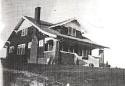
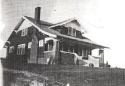
 Here is a record of our restoration of a 1928 craftsman. We will be the second family to live in the home. Watch our progress when we prevail and our privation and pratfalls as we do not.
Today's Iowa City Press Citizen contains a little guest opinion written by yours truly regarding other major floods in Iowa City history. Here is their published version of what I wrote:
Is this the worst flood in city history?
MIKE HAVERKAMP • GUEST OPINION • JUNE 21, 2008
While we have been horrified by the images of devastation, the 2008 flood may not be Iowa City's worst flood in the past century. While the media rightly notes that this flood is much worse than 1993, if you trace back just slightly more than 150 years, the flood of 2008 may rank as only the fourth worst to hit Iowa City.
In June 1918 there was no Coralville Reservoir to hold back the Iowa River. After an exceptionally rainy spring, major flooding struck Iowa City on June 6, 1918. According to an 1985 article by Irving Weber, Iowa City was without electricity for three days: In the same article, Weber goes on to say:
"During the 1918 flood the lower area of City Park was 12 to 15 feet under water. At its crest, water flowed over the wood planking of the iron arched Park Bridge.
"Probably the greatest disaster of all was the fate of the three large Englert Ice Houses loaded with 9,000 tons of Iowa River ice. It was the first time in history the Iowa River was filled with ice in June."
Weber also gives the reminisces of Madison Street resident Fred Gartzke, whose boyhood home was at the site of the present Iowa Memorial Union:
"I recall paddling a canoe down Madison past the Water Works plant, which had been sandbagged to the first floor windows to keep the flood waters out. A mark on the west door shows the height of the 1918 flood."
That high water mark on the Water Works door was also recalled by University of Iowa Facilities Services Group Assistant Director Al Stroh in an article commemorating the 10th anniversary of the 1993 flood: "Although the flood of '93 was bad, the water level was still almost four feet below the flood of 1918 -- as marked on the west side of the old city water plant."
Current Iowa Citians often forget that a large part of the area along Capitol Street -- from Benton Street to the south and the Iowa Memorial Union to the north -- were residential homes until the 1920s. Many of these homes in this 10-blocks-long and two-blocks-wide area were subject to frequent flooding.
So which was worse, 2008 or 1918?
It depends on how you count.
U.S. Geological Survey records for the Iowa City stage south of the Burlington Street dam as follows:
• June 6-8, 1918: Maximum gage, 19.6 feet; maximum flow, 42,500 cubic feet per second.
• June 15-16, 2008: Maximum gage, 31.5 feet; maximum flow, 41,100 cfs.
Gage is difficult to compare over time because the bottom of the river does change. So 2008 had a higher gage but at 42,500 cfs, 1918 may still rank as worse.
What about the infamous line on the old Water Works door?
Sadly, last week a group of Iowa City School District teachers and I went to the Water Works to get a picture of it, but we could find no line anywhere. When I walked down to the Water Works at 1 p.m. Monday, I could see that the water was up to the sills of the first floor windows, so it may be best to say that 1918 and 2008 are tied.
What of the two floods that were worse?
In a 1975 article, Weber describes how he tried to find out what the record floods were:
"Sam Mummey of the U.S. Geological Survey has provided figures showing the river stages since records were kept annually at Iowa City, beginning June 3, 1903. In addition, the years 1851 and 1881 are recorded, though the 1851 figures are qualified with the notation "about."
• July 10, 1881: Maximum gage, 21.1 feet; maximum flow, 51,000 cubic feet per second.
• June 1, 1851: Maximum gage, 24.1 feet; maximum flow, 70,000 cubic feet per second.
Weber concludes his article with the statement:
"Indians still in the area in 1851 indicated they knew of one other flood which their mark west of the Old Capitol showed was one foot higher than the 1851 flood. The year of the 'Indian Flood' is not known."
As we face the daunting task of repairing our community after this tragedy, I hope my neighbors will take some small solace in "it could have been worse..."
Mike Haverkamp is an Iowa City School District teacher and amateur history buff.
A companion piece that ran with it was written by local history expert Bob Hibbs:
Measuring water flow vs. human misery
Bob Hibbs • Iowa City: A Sense of Place • June 21, 2008
If Mike Haverkamp claims the 2008 flood at Iowa City is the fourth worst on record -- behind 1851, 1881 and 1918 -- I suspect the claim fairly reflects reality. On the misery scale, however, 2008 is without doubt the tops because far more people are affected.
Some interpretation is needed when Irving Weber writes that, during the 1918 flood, "City Park was 12 to 15 feet under water" because much of the park has been filled substantially during intervening years. The river also has been moved west of its original historic location that was much closer to the site of today's Mayflower Residence Hall.
Many City Park areas have been elevated by four feet, while others are as much as eight or 10 feet higher now than would have been the case during the 1918 flood. The Normandy Drive neighborhood -- a.k.a. "Mosquito Flats" -- also has been filled substantially. These fills at City Park and Normandy Drive without doubt have added substantially to the flooding of Coralville along Clear Creek, making comparisons far more complex.
But is it the water level or the misery that should be measured? Far more people affected today, so this is worse -- right?
Consider this photograph showing the old and new Park Road bridges beside each other in 1961. The decks seem to be at similar elevations. Given Weber's comment that "water flowed over the wood planking" in 1918, and given the Press-Citizen's reporting of water at the bridge deck in 2008, could it be that water levels may have been comparable during 1918 and 2008 at that site?
Gage levels in feet rarely provide comparable data, often are misleading and often misinterpreted. On the other hand, the cfs flow data might be good, depending on source. Any hydrologist from ancient times could figure the area of a river cross-section, determine incline and from those data compute flows. They are always "about" or "approximate," although those words are rarely used. The "Indian Flood" is prehistoric, and there were no doubt many floods during that era that far, far exceeded anything that has occurred during historic times. Prehistoric times should not be mixed with the historic record.
Of course this leads to the questions about whether we should be building at all in floodplains. Has our Athens of Iowa demonstrated adequate leadership in floodplain management? Oh, watch out, we could get into a serious contemporary discussion.
Bob Hibbs is the author of "Iowa City: A Sense of Place," volumes one and two, published by the Press-Citizen.
We'll see if anyone comments on their online site:
Haverkamp Article
Hibbs Article
Showing posts with label flood. Show all posts
Showing posts with label flood. Show all posts
Saturday, June 21, 2008
Sunday, June 15, 2008
Ride the River
In Father's Days past we have packed our bicycles and done Ride the River in the Quad Cities with Lisa's sister and her husband. Since we couldn't get to Rock Island (I-80 is closed east of Iowa City) We did our own ride the river tours today.
I rode over to my office this morning. Burlington St. bridge is still open, but wet since they are pumping out of UI Main Library and Lindquist buildings onto the street.
Tech Center is still dry. Here is the water across the street

And the water below our building at the corner of Capitol and Benton:

I came back over the Benton St. Bridge. Here is a closeup of the downriver side of Burlington St. Bridge. The large rusty thing at the top of the picture is the Iowa Interstate Railroad Bridge the highest span across the river in Iowa City.

Lisa and the girls and I rode on the tandem and the tag along to see the water later. Our first stop was Hawkins Drive and Highway 6 below Carver Hawkeye Arena. The water is up pretty high on the railroad overpass above Rocky Shore Drive:

Then we rode over to the UI west side arts campus. Water has come up to the back of Hancher Auditorium, the premiere performance stage in town:

It has also surrounded E.C. Mabie Theater. I performed in the UI's Summer Rep Theater on that stage in 1979.

Beyond Mabie is the UI Art Museum, all the works have been evacuated, including the giant Jackson Pollack.

(photo from: http://farm1.static.flickr.com/116/303258959_348126bcbd.jpg?v=0)
We then went to City Park. Lower Park is completely flooded. Here is the now submerged Park Road Bridge:

I then walked alone around Upper Park and came down to take a picture of Lucky Shelter #13, the one that we always rent for 4th of July picnics:

The GOOD NEWS is that there are some indications that the Coralville Resevoir may have crested last night, it was predicted to not crest until tomorrow. That is dependant on the amount of rain we continue to receive. However if that is true, we may crest 1.5 feet LOWER than predicted.
I told Rowan today on the ride that we have now at least tied 1918 flood level records, which were higher than 1993.
I rode over to my office this morning. Burlington St. bridge is still open, but wet since they are pumping out of UI Main Library and Lindquist buildings onto the street.
Tech Center is still dry. Here is the water across the street
And the water below our building at the corner of Capitol and Benton:
I came back over the Benton St. Bridge. Here is a closeup of the downriver side of Burlington St. Bridge. The large rusty thing at the top of the picture is the Iowa Interstate Railroad Bridge the highest span across the river in Iowa City.
Lisa and the girls and I rode on the tandem and the tag along to see the water later. Our first stop was Hawkins Drive and Highway 6 below Carver Hawkeye Arena. The water is up pretty high on the railroad overpass above Rocky Shore Drive:
Then we rode over to the UI west side arts campus. Water has come up to the back of Hancher Auditorium, the premiere performance stage in town:
It has also surrounded E.C. Mabie Theater. I performed in the UI's Summer Rep Theater on that stage in 1979.
Beyond Mabie is the UI Art Museum, all the works have been evacuated, including the giant Jackson Pollack.
(photo from: http://farm1.static.flickr.com/116/303258959_348126bcbd.jpg?v=0)
We then went to City Park. Lower Park is completely flooded. Here is the now submerged Park Road Bridge:
I then walked alone around Upper Park and came down to take a picture of Lucky Shelter #13, the one that we always rent for 4th of July picnics:
The GOOD NEWS is that there are some indications that the Coralville Resevoir may have crested last night, it was predicted to not crest until tomorrow. That is dependant on the amount of rain we continue to receive. However if that is true, we may crest 1.5 feet LOWER than predicted.
I told Rowan today on the ride that we have now at least tied 1918 flood level records, which were higher than 1993.
Saturday, June 14, 2008
As IF We Didn't Have Enough Water!
I did make it across both of the last two bridges left open this morning. After thinking about it last night, I went back to my office and removed some of the items that I had moved to second floor. Given that we are now supposed to get a foot more water than had been predicted, it gives me peace of mind to get most of my files, etc. out of the office. I also brought home my great-grandmother's wicker plant stand, if things get wet and humid inside, I didn't think even leaving it on second floor was a good idea.
Per a request from my most devoted local Iowa City reader, here is a picture of the girls' backyard swimming pool:

This is a new pool, replacing the pool we used for the last two years:

The old pool had a 12 foor diameter and was 2 and a half feet tall. The new pool is 13 feet in diameter and 3 and four feet tall.
We filled it with half city water and half rain water. If I had diverted my downspout I could have completely filled it with rain water!
Iowa City officials have said they do NOT expect to lose the water works to flooding but I am taking no chances: youngest daughter is under strict orders NOT to pee in the pool! While we COULD drink it after boiling, I'm telling the neighborhood that we have supply to flush toilets if needed.
Speaking of pools here is the fish pool with rainwater, the dirt bottom makes it look bad. This is a weird shot with the reflection of the neighbor's garage in it:

Obligatory flood shot: Here are the girls sitting on a sandbag wall at the QuickTrip enjoying our slushies after riding along Riverside Dr. yesterday:

Per a request from my most devoted local Iowa City reader, here is a picture of the girls' backyard swimming pool:
This is a new pool, replacing the pool we used for the last two years:
The old pool had a 12 foor diameter and was 2 and a half feet tall. The new pool is 13 feet in diameter and 3 and four feet tall.
We filled it with half city water and half rain water. If I had diverted my downspout I could have completely filled it with rain water!
Iowa City officials have said they do NOT expect to lose the water works to flooding but I am taking no chances: youngest daughter is under strict orders NOT to pee in the pool! While we COULD drink it after boiling, I'm telling the neighborhood that we have supply to flush toilets if needed.
Speaking of pools here is the fish pool with rainwater, the dirt bottom makes it look bad. This is a weird shot with the reflection of the neighbor's garage in it:
Obligatory flood shot: Here are the girls sitting on a sandbag wall at the QuickTrip enjoying our slushies after riding along Riverside Dr. yesterday:
Subscribe to:
Posts (Atom)